
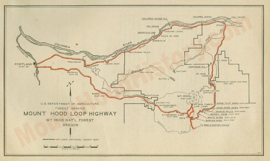
Mount Hood Loop Highway
I’ve lived on the old Columbia River Highway in Bridal Veil, and currently live along the course of the Barlow Trail in Brightwood. My love of the Columbia River Gorge and Mount Hood, and my interest in their history has driven my research into the story of both routes and the development of the Mount Hood Loop Highway. Mount Hood is the only glacial peak with a road that completely circles it allowing access to the peak from every direction. It’s a fun day when I can relax and go for a drive the Mount Hood Loop Highway.
 Before the immigrants from the East came to settle here the native people had well beaten trails that led from the Columbia River, located to the north, and from the Willamette Valley to the west. The trails led to the hills on the southwest side of the mountain where they would come to hunt, fish, gather berries and harvest medicinal plants.
In the early days of the Oregon Trail the “Great River of The West, the Columbia River, was used by the immigrants on their surge west. Many families rafted what was left of their earthly belongings, and in many cases what was left of their families, down the perilous river route through cascading rapids and laborious portages to the Willamette Valley in search of the “Land of Milk and Honey”. Because of this migration, the initial establishment of the overland roads by and large carried traffic from east to west following game and native trails, the primary route being over the southern shoulder of Mount Hood.
Sam Barlow and Joel Palmer arrived in charge of separate wagon trains at The Dalles in September of 1845 and found a shortage of everything, and a long wait for the dicey trip down the river. They both felt that the prospect of staying in The Dalles until a guide could be secured was more than their patience or their budget could endure. Considering the fare charged by the River Guides and the expensive prices for supplies at The Dalles, and the fact that the trip was not just a leisurely float downstream, a land route around Mount Hood sounded like a good idea. Hearing of Sam Barlow’s plan to cross the southern shoulder of Mount Hood, Joel Palmer decided to follow him with his own wagon train, overtaking them soon after.
Moving south along the Deschutes and up the White River they burned and slashed their way to the south shoulder of Mount Hood before succumbing to the arduous labor and the oncoming winter weather which required them to stash their wagons and head in the most expedient way to Fosters Farm and on to Oregon City, with the weaker ones of the party riding their tired stock. December of that same year found Samuel Barlow petitioning the territorial government for a permit to operate a toll road over the path that he and his companions traveled the previous October.
In time several routes were pushed through the Columbia River gorge to the valley, including supply/trade and cattle trails as well as a Military road. By the 1880’s railroads were running through, and of course in 1913 the first paved road was built through in the form of the Scenic Columbia River Highway, of which much has been written.
Meantime on the South side of Mt. Hood Sam Barlow’s road was changing too. Nearly put out of business by the gorge routes, the old Barlow road went through many private hands and states of repair and disrepair before it was handed over to the state to be developed into a highway, much along the same route that we drive today along Highway 26.
 By the late 1800’s the immigrants had established their civilization and now many of the next generation wanted to play in the outdoors that their parents fought to survive in fifty years before. Mount Hood is in Portland’s back yard and it beckoned from its position on the horizon visible from most any part of the city, calling them to the mountains. Outdoor sports were very popular then, much like they are today, and many would take the road to the mountain for a guided trip to the summit, or as time went by to the ski slopes in the winter. Summer found them taking wonderful alpine hikes, festooned with breathtaking vistas, fields of wildflowers, creeks and lakes. Fishing and hunting trips were also taken to teaming rivers and the forests abundant with wild game.
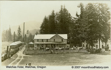
Mountain lodges and road houses were established to cater to the tourists, including Welch’s Ranch and Tawny’s Mountain Home as transportation methods and road conditions improved. Horse drawn stages and then auto stages started regular runs from Portland to Mount Hood and back. Many would stop and stay at Welches and others would make the trip to Government Camp where the guides would take them to the top of the mountain.
In 1911 E. Henry Wemme, an automobile enthusiast and Portland businessman, purchased the old road from the Mount Hood & Barlow Road Company with the intentions of improving the route to the mountain and points east for the automobile that was to become the new wave of modern transportation. Two years later he offered the road to the government, who turned down his offer. He died the following year and willed the road to his attorney, who in 1917 presented it to the state who removed the tolls on the road and took over maintenance. By that time there had already been talk of plans for a road that would allow travel completely around Mount Hood.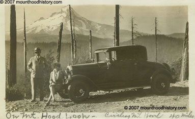
In 1914 Thomas H. Sherrard, supervisor for the Mount Hood National Forest along with William L. Finley, a naturalist, Rufus Holman, the Multnomah County Commissioner, Leslie Butler and Charles Bell from Hood River and Jacob Kanzler of Portland took a horseback trip around the east side of the mountain much along the route of the present highway 35, which created more interest and faith in the feasibility of a route that would follow the upper Hood River Valley around the east side to the Wapanitia cutoff and the south side road.
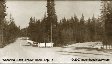
In 1919 a cooperative agreement was signed between the state and the government to build the road. It was started late in the year of 1919, and was completed in late 1924. The first traffic to follow the new road came in the summer of 1925 after the winter snows cleared. The road was only used seasonally until improvements were made and snow removal started in 1967.
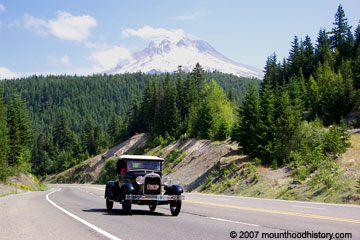
And so the Mount Hood Loop Highway was complete. Fred McNeil wrote that at its dedication the Mount Hood Loop road was called “The necklace about the old volcano with Portland as its pendant”. The Loop hasn’t lost much of its allure since then and is travelled often today by folks out for a “Sunday Drive”. It is easily travelled in a day, including stops for pictures of mountain vistas, waterfalls and lunch. If anything has been lost, it’s the lack of awareness of what is being passed unnoticed by those that are “making tracks” and not “smelling the rhodies” while encapsulated in their climate controlled, surround sound equipped cocoons that travel at speeds not thought of by the pioneers that traveled before them.
 Do yourself a favor the next time that you are looking for adventure and take the Mount Hood Loop Highway and please, stop and read an historical marker, or visit a museum. There are many shops and restaurants along the way that are just waiting to be discovered as well. If you’ll leave your cocoon and take a side trip or two and stop and smell the rhodies, maybe you’ll figure out why I love my neighborhood so much. Oh, and wave as you pass Brightwood, it’s right off the highway on a great stretch of the old road.
Click here to see vintage pics from the old Mount Hood Loop Highway from Wemme to Hood River.
Click here for Mount Hood Loop Map
Wonderful information and good writing. Thanks.
You added new dimensions to my trips around Mt Hood.
I’m doing it on a bicycle next. I’ll be using your research to inform my ride experience.
Thank You